


Average elevation gain
 10-01-23, 09:10 PM
#76
Senior Member
Join Date: Sep 2017
Posts: 7,887
Mentioned: 38 Post(s)
Tagged: 0 Thread(s)
Quoted: 6972 Post(s)
Liked 10,968 Times
in
4,692 Posts
i still question the usefulness of this metric. i often read that 100 ft/mi is some sort of benchmark. but that is not quite a 2% grade. i doubt most here are riding 2% grades from start to finish. most of mine are 5+%. maybe a better metric would be average grade for distances with grades > 0%?
Of course, not all 100ft/mi rides are equal, either: I've done some of the biggest hill climb races in Colorado, which involve far more than 100ft/mi -- some over double that ratio. And yet, some races out in WV and PA which have around 100ft/mi (give or take) were waaaay harder, because the climbs were steeper (albeit shorter, and with descents). Much harder to modulate your aerobic effort.
Again, I know of no program for doing this...But yeah. Spreadsheets are useful, but they won't do that.
 10-01-23, 09:35 PM
#77

Senior Member
Join Date: May 2021
Location: San Francisco
Posts: 2,039
Bikes: addict, aethos, creo, vanmoof, sirrus, public ...
Mentioned: 2 Post(s)
Tagged: 0 Thread(s)
Quoted: 1279 Post(s)
Liked 1,393 Times
in
711 Posts
nah, given the nature of the XML schema for bike rides, you could pretty easily do this. break the tags onto columns, one row per trackpoint, a simple if statement referencing the elevation and distance of the prior and current row gives you the grade between those two points. then another statement discarding that point if the grade is less than some selected percentage. weight the remaining grades by the distance they represent, and there you go. you could make a histogram or averages or whatever you want.
__________________

10-01-23, 09:45 PM
#78
Senior Member
Join Date: Sep 2017
Posts: 7,887
Mentioned: 38 Post(s)
Tagged: 0 Thread(s)
Quoted: 6972 Post(s)
Liked 10,968 Times
in
4,692 Posts
nah, given the nature of the XML schema for bike rides, you could pretty easily do this. break the tags onto columns, one row per trackpoint, a simple if statement referencing the elevation and distance of the prior and current row gives you the grade between those two points. then another statement discarding that point if the grade is less than some selected percentage. weight the remaining grades by the distance they represent, and there you go. you could make a histogram or averages or whatever you want.
Serious request. I'm genuinely curious.
10-02-23, 11:52 AM
#80
Senior Member
Join Date: May 2021
Location: San Francisco
Posts: 2,039
Bikes: addict, aethos, creo, vanmoof, sirrus, public ...
Mentioned: 2 Post(s)
Tagged: 0 Thread(s)
Quoted: 1279 Post(s)
Liked 1,393 Times
in
711 Posts
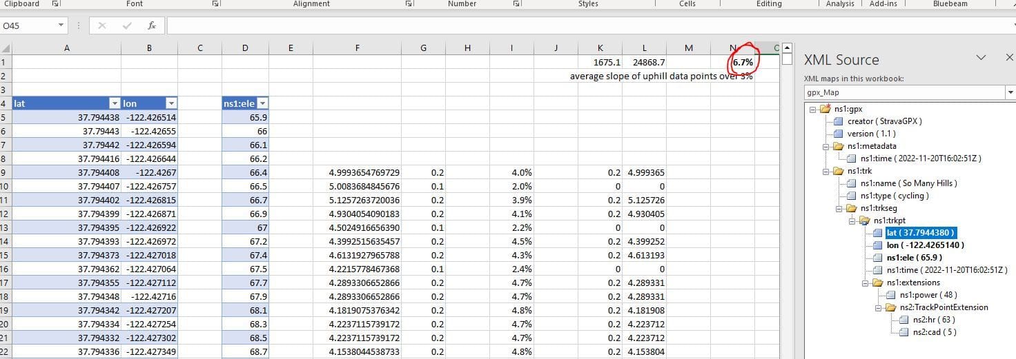
import gpx (as XML) into excel. depending on your data source, some of the elements of the scheme may not be recognized - i ignored errors related to additional data like power balance and so on. from XML source tab, drop lat, lon, and elevation into columns. fill those columns with the data.
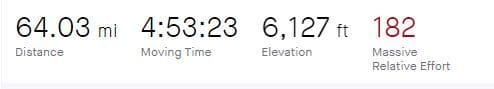
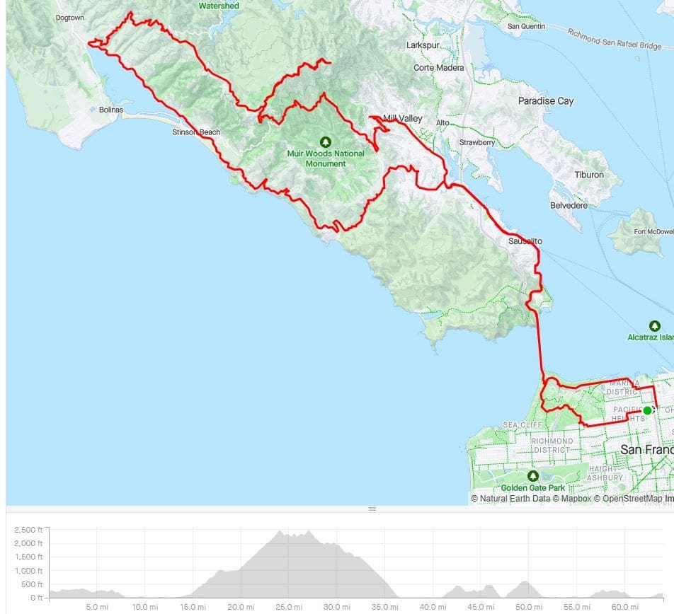
this scheme didn't have distance, so i added the formula to calculate distance from latitude and longitude into column F, returns meters. column G is the change in elevation. column I is the change in elevation over the distance. column K is the change in elevation if it's greater than 3%, and 0 otherwise. column L is the distance if the change in elevation is greater than 3%, and 0 otherwise. K1 and L1 are the sum of those columns, and N1 (bolded number) is the percentage slope in aggregate. this is about what i'd expect - most roads in the bay area are graded to around 6% when they're going uphill. this ride was 64 miles and 6,127 feet of climbing. if you just used those numbers and assumed you went up half the time, then down half the time, you'd get 3.6%, obviously wrong.
this took about 5 minutes plus about 5 minutes refreshing my memory on how to fill the XML data into the columns. it would take about one minute per ride now.
strava summary:
__________________
10-02-23, 12:53 PM
#81
Senior Member
Join Date: Sep 2017
Posts: 7,887
Mentioned: 38 Post(s)
Tagged: 0 Thread(s)
Quoted: 6972 Post(s)
Liked 10,968 Times
in
4,692 Posts
strava -> export to gpx.
import gpx (as XML) into excel. depending on your data source, some of the elements of the scheme may not be recognized - i ignored errors related to additional data like power balance and so on. from XML source tab, drop lat, lon, and elevation into columns. fill those columns with the data.
this scheme didn't have distance, so i added the formula to calculate distance from latitude and longitude into column F, returns meters. column G is the change in elevation. column I is the change in elevation over the distance. column K is the change in elevation if it's greater than 3%, and 0 otherwise. column L is the distance if the change in elevation is greater than 3%, and 0 otherwise. K1 and L1 are the sum of those columns, and N1 (bolded number) is the percentage slope in aggregate. this is about what i'd expect - most roads in the bay area are graded to around 6% when they're going uphill. this ride was 64 miles and 6,127 feet of climbing. if you just used those numbers and assumed you went up half the time, then down half the time, you'd get 3.6%, obviously wrong.
this took about 5 minutes plus about 5 minutes refreshing my memory on how to fill the XML data into the columns. it would take about one minute per ride now.
I've never worked with that sort of data in excel before, so was curious how you'd do it. Looks like you and rsbob were right, and I was wrong!
Relating to the original question, this might be a more appealing measure for some riders, and might more accurately depict the difficulty of certain rides. I once did this event, which is all about the climbs -- most of which are over 20%, with one hitting a 37% grade. The riding in-between hills is pretty irrelevant, so an average of the actual climbing would be an interesting number. But I do think that most riders will stick to the ft/mi metric for the entire ride.
10-02-23, 01:33 PM
#82
Senior Member
Join Date: Jul 2015
Location: reno, nv
Posts: 2,301
Bikes: yes, i have one
Mentioned: 2 Post(s)
Tagged: 0 Thread(s)
Quoted: 1138 Post(s)
Liked 1,182 Times
in
687 Posts
so although going by the more traditional feet/mi metric this ride comes in at less than 100 ft/mi or less than 2%. the 6.7% that you calculated seems like it makes more sense to me. now i just have to let that soak in. i use strava as a ride repository but then pull it all down to my PC so i think i'll add this to my app and see how much i like this metric.
10-02-23, 01:56 PM
#83
Perceptual Dullard
Join Date: Sep 2009
Posts: 2,421
Mentioned: 36 Post(s)
Tagged: 0 Thread(s)
Quoted: 919 Post(s)
Liked 1,156 Times
in
494 Posts
Very nice. Years ago I used to do something similar but with power and speed data: I'd calculate the virtual slope based on speed and power and then use that to get the "weighted slope" conditional on the slope > x where x is a small positive number like 1%. This is virtual slope, so it includes wind -- a headwind increases virtual slope while a tailwind diminishes it. Conditioning on x>0 removes flats and downhills, mostly: the mostly is cuz of headwinds. I thought this might be better indication of how "tough" a ride was; the same route on a calm vs. windy day would have a different virtual elevation gain. I thought a little bit about the proportion of Joules allocated to virtual climbing to total Joules used during the ride but I sorta gave up after that cuz no one understood back then what I meant by virtual elevation.
10-02-23, 02:57 PM
#84
Senior Member
Join Date: May 2021
Location: San Francisco
Posts: 2,039
Bikes: addict, aethos, creo, vanmoof, sirrus, public ...
Mentioned: 2 Post(s)
Tagged: 0 Thread(s)
Quoted: 1279 Post(s)
Liked 1,393 Times
in
711 Posts
Very nice. Years ago I used to do something similar but with power and speed data: I'd calculate the virtual slope based on speed and power and then use that to get the "weighted slope" conditional on the slope > x where x is a small positive number like 1%. This is virtual slope, so it includes wind -- a headwind increases virtual slope while a tailwind diminishes it. Conditioning on x>0 removes flats and downhills, mostly: the mostly is cuz of headwinds. I thought this might be better indication of how "tough" a ride was; the same route on a calm vs. windy day would have a different virtual elevation gain. I thought a little bit about the proportion of Joules allocated to virtual climbing to total Joules used during the ride but I sorta gave up after that cuz no one understood back then what I meant by virtual elevation.
10-02-23, 03:02 PM
#85
Senior Member
Join Date: Jul 2015
Location: reno, nv
Posts: 2,301
Bikes: yes, i have one
Mentioned: 2 Post(s)
Tagged: 0 Thread(s)
Quoted: 1138 Post(s)
Liked 1,182 Times
in
687 Posts
the difficulty here is knowing the wind direction. RChung, you don't mention location but here in Reno the wind blows every which direction possible. i don't fault the NOAA but their data is just not accurate.
10-02-23, 03:08 PM
#86
Senior Member
Join Date: May 2021
Location: San Francisco
Posts: 2,039
Bikes: addict, aethos, creo, vanmoof, sirrus, public ...
Mentioned: 2 Post(s)
Tagged: 0 Thread(s)
Quoted: 1279 Post(s)
Liked 1,393 Times
in
711 Posts
the difficulty here is knowing the wind direction. RChung, you don't mention location but here in Reno the wind blows every which direction possible. i don't fault the NOAA but their data is just not accurate.
__________________
Likes For mschwett:
10-02-23, 04:46 PM
#87
Perceptual Dullard
Join Date: Sep 2009
Posts: 2,421
Mentioned: 36 Post(s)
Tagged: 0 Thread(s)
Quoted: 919 Post(s)
Liked 1,156 Times
in
494 Posts
Yup. I was always confused by rides classified by average elevation gain per mile -- I was more concerned by the length and difficulty of the hardest climbs during the ride, not the average. Eventually I realized that with power and speed data, I could tell when I was putting out a lot of power for not much speed (and vice versa) and that was a closer measure of difficulty, and it didn't matter so much whether it was hard because of the slope or the wind: they scale differently, but they're both hard so I converted winds into "equivalent" elevation. I also looked at converting slope into wind, but the pattern there was harder to discern.
10-02-23, 06:54 PM
#88
Senior Member
Join Date: Jul 2015
Location: reno, nv
Posts: 2,301
Bikes: yes, i have one
Mentioned: 2 Post(s)
Tagged: 0 Thread(s)
Quoted: 1138 Post(s)
Liked 1,182 Times
in
687 Posts
Yup. I was always confused by rides classified by average elevation gain per mile -- I was more concerned by the length and difficulty of the hardest climbs during the ride, not the average. Eventually I realized that with power and speed data, I could tell when I was putting out a lot of power for not much speed (and vice versa) and that was a closer measure of difficulty, and it didn't matter so much whether it was hard because of the slope or the wind: they scale differently, but they're both hard so I converted winds into "equivalent" elevation. I also looked at converting slope into wind, but the pattern there was harder to discern.
this particular metric seems more useful but i suppose that is what TSS is for. i wonder, does TSS go down as a ride accumulates distance at an easy pace or more descents? or maybe it just does not increase. thinking out loud, not looking for an answer.
10-03-23, 10:17 AM
#89
Perceptual Dullard
Join Date: Sep 2009
Posts: 2,421
Mentioned: 36 Post(s)
Tagged: 0 Thread(s)
Quoted: 919 Post(s)
Liked 1,156 Times
in
494 Posts
I believe that if you add some zero power time at the end of a ride (for example, if your head unit somehow continues to record zeroes after the end of your ride), the "new" TSS for the "new" ride duration will continue to increase. I mentioned this to Andy Coggan 20 years ago when he first proposed TSS and he said, "make sure your head unit doesn't do that." But, as has been pointed out to me recently, the things and behaviors I find odd most people don't.
10-03-23, 11:24 AM
#90
climber has-been

Join Date: Dec 2004
Location: Palo Alto, CA
Posts: 7,111
Bikes: Scott Addict R1, Felt Z1
Mentioned: 10 Post(s)
Tagged: 0 Thread(s)
Quoted: 3432 Post(s)
Liked 3,567 Times
in
1,793 Posts
Sometimes, average elevation gain does not tell the story. At least not the important part.
Here's an example of a route that feels much harder than the average would indicate. It's 51 miles, but it has only about 63 feet per mile.
It has several short but steep climbs that beat mightily on my legs. The final climb has an extended section at 15%, at which point I find myself uttering curse words to nobody in particular.
I'm resolved to repeat this route until it becomes easy (or at least easier).
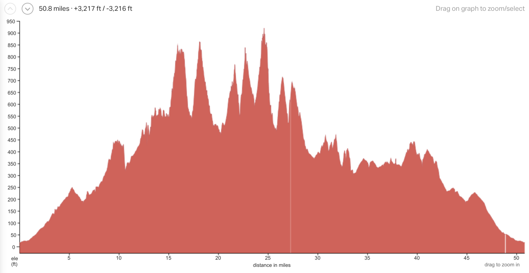
Steep roads of Los Gatos 51
Here's an example of a route that feels much harder than the average would indicate. It's 51 miles, but it has only about 63 feet per mile.
It has several short but steep climbs that beat mightily on my legs. The final climb has an extended section at 15%, at which point I find myself uttering curse words to nobody in particular.
I'm resolved to repeat this route until it becomes easy (or at least easier).
Steep roads of Los Gatos 51
__________________
Ride, Rest, Repeat. ROUVY: terrymorse

Ride, Rest, Repeat. ROUVY: terrymorse
10-04-23, 12:03 PM
#91
Senior Member
Join Date: Aug 2009
Posts: 1,814
Mentioned: 5 Post(s)
Tagged: 0 Thread(s)
Quoted: 501 Post(s)
Liked 631 Times
in
373 Posts
Our usual 40-60 mile rides have 2000 feet or so, but it's all annoying rollers and short humps that just break up rhythm more than anything.
10-06-23, 09:08 AM
#92
Senior Member

Join Date: Mar 2023
Location: NorCal
Posts: 505
Bikes: Santa Cruz Blur 4 TR, Canyon Endurace cf sl, Canyon Ultimate cf slx, Canyon Strive enduro, Canyon Grizl sl8
Mentioned: 0 Post(s)
Tagged: 0 Thread(s)
Quoted: 219 Post(s)
Liked 847 Times
in
342 Posts
Rides with short, steep climbs are actually easier for me...the type of climbs that I'm riding above threshold for 5-20 minutes. I'm the type of rider with a good "VO2max" type power, with repeatability. The rides with big, long climbs are the ones that wear me down. There are several climbs that I ride semi-regularly, 3000-3500' of gain and take roughly an hour to climb. Doing 2 of those climbs in one ride feels considerably more difficult, to me, than doing a ride with 6000' of punchy climbing.
10-06-23, 11:04 AM
#93
climber has-been
Join Date: Dec 2004
Location: Palo Alto, CA
Posts: 7,111
Bikes: Scott Addict R1, Felt Z1
Mentioned: 10 Post(s)
Tagged: 0 Thread(s)
Quoted: 3432 Post(s)
Liked 3,567 Times
in
1,793 Posts
Rides with short, steep climbs are actually easier for me...the type of climbs that I'm riding above threshold for 5-20 minutes. I'm the type of rider with a good "VO2max" type power, with repeatability. The rides with big, long climbs are the ones that wear me down. There are several climbs that I ride semi-regularly, 3000-3500' of gain and take roughly an hour to climb. Doing 2 of those climbs in one ride feels considerably more difficult, to me, than doing a ride with 6000' of punchy climbing.
I'm kind of the opposite. Short, punchy climbs wear me out quickly (my legs, specifically), but I can tempo climb for several hours before fatigue sets in. At least I could in years past.
__________________
Ride, Rest, Repeat. ROUVY: terrymorse
Ride, Rest, Repeat. ROUVY: terrymorse
10-06-23, 12:31 PM
#94
Senior Member
Join Date: Mar 2023
Location: NorCal
Posts: 505
Bikes: Santa Cruz Blur 4 TR, Canyon Endurace cf sl, Canyon Ultimate cf slx, Canyon Strive enduro, Canyon Grizl sl8
Mentioned: 0 Post(s)
Tagged: 0 Thread(s)
Quoted: 219 Post(s)
Liked 847 Times
in
342 Posts
Interesting. Do you think your lactate threshold is relatively low compared to VO2max?
I'm kind of the opposite. Short, punchy climbs wear me out quickly (my legs, specifically), but I can tempo climb for several hours before fatigue sets in. At least I could in years past.
I'm kind of the opposite. Short, punchy climbs wear me out quickly (my legs, specifically), but I can tempo climb for several hours before fatigue sets in. At least I could in years past.
My 1 through 5 minute power numbers have always been very good compared to my FTP(at least since I've been using a power meter.) Oddly enough, I wouldn't call myself a sprinter either...as my 10 second power numbers are good, but not the "superlative" amount that my 1-5 are. I did go a long way in improving my endurance this year, FTP made big gains, as well as everything but my pure sprint power. I even set a PR for 1 minute power this year.
Last edited by Sierra_rider; 10-06-23 at 12:37 PM.
Likes For Sierra_rider:

Thread
Thread Starter
Forum
Replies
Last Post
AllWeatherJeff
Long Distance Competition/Ultracycling, Randonneuring and Endurance Cycling
26
07-02-19 01:36 PM
